Route risk assessment helps rail operators identify local hazards, prioritise controls, and strengthen route knowledge. Therefore, organisations can focus safety activity on genuine operational risks.
For traincrew, route knowledge extends far beyond remembering station names or locations. Staff must also understand how individual route features could influence safe decisions.
Those features may include gradients, crossings, signal sighting, unusual stations, and low adhesion areas. In addition, local instructions and operational interfaces can introduce further challenges.
Route risk mapping brings this information together within a clear visual resource. As a result, staff can recognise developing risks earlier and respond with greater confidence.
However, a map alone cannot improve safety. Organisations must connect its information with training, competence assessment, operational learning, and regular review.
When these elements work together, route knowledge becomes practical. Consequently, people understand how the railway behaves across normal, degraded, and emergency conditions.
Why Every Railway Route Requires Individual Attention
Every railway route has its own operational character. Therefore, a general risk profile cannot represent every local hazard, condition, or operational demand.
Some hazards appear immediately during route review. Others only become clear through experience, incident evidence, staff feedback, or changing operating conditions.
For example, a complex junction may increase workload during disruption or poor visibility. Meanwhile, frequent speed changes may complicate a demanding station approach.
Another route may include restricted signal sighting, steep gradients, or several high-risk crossings. Seasonal low adhesion could then increase braking risk at specific locations.
These features rarely exist in isolation. Instead, several nearby hazards may interact and create a more demanding operational situation.
Therefore, operators need to consider each feature within its wider route context. They should examine how location, timing, weather, workload, and traffic patterns interact.
Route knowledge should explain how the railway behaves, not simply where each asset sits. Because conditions change, staff must anticipate how familiar locations could become harder.
This deeper understanding supports safer decisions under pressure. It also helps people recognise developing situations before those situations become difficult to manage.
What Is Route Risk Assessment?
Route risk assessment identifies hazards along a defined route and evaluates the risks they create. It then helps organisations judge whether existing controls remain suitable.
The process should combine infrastructure information, operating instructions, incident data, and frontline experience. Therefore, it creates a fuller picture than any single source provides.
RSSB’s Management of Route Knowledge standard covers route knowledge training, development, monitoring, and assessment. Consequently, it provides an important reference for relevant organisations.
A structured assessment should explore several practical questions:
- Which hazards exist along the route?
- Where are the higher-risk locations?
- Which locations feature in previous incidents or near misses?
- Which local conditions could affect safe operation?
- How frequently might staff encounter each hazard?
- What consequences could follow ineffective management?
- Which controls already reduce the risk?
- Where could further training, briefing, or assessment help?
These questions move teams beyond general awareness. Instead, they support clear priorities for locations and situations that require closer attention.
Two routes may use similar rules while presenting very different challenges. Therefore, route-specific analysis remains essential for practical safety management.
Which Route Hazards Should Organisations Consider?
A useful route risk assessment considers both obvious infrastructure hazards and less visible operational pressures. However, each organisation must define hazards around its actual activities.
Physical features may include signals, gradients, curves, tunnels, crossings, junctions, and platform arrangements. In addition, restricted clearances or unusual layouts may require specific attention.
Operational factors can include frequent speed changes, complex dispatch arrangements, traction restrictions, or demanding braking points. Likewise, service intensity may influence workload at particular locations.
Environmental conditions also matter. Poor visibility, flooding, vegetation, snow, and seasonal low adhesion may change how staff approach familiar parts of the route.
Human and organisational factors deserve equal consideration. For example, unclear instructions, competing communications, distraction, fatigue, or limited experience can increase risk.
Interfaces may introduce further complexity. Traincrew could need to coordinate with signallers, controllers, station teams, infrastructure staff, or other operators.
Therefore, the assessment should examine hazards as connected elements. A manageable feature can become more significant when weather, workload, and disruption occur together.
How Route Risk Mapping Improves Understanding
Route risk mapping turns assessment findings into an accessible visual resource. A useful map can present hazards, controls, features, and higher-risk areas within context.
The route risk assessment provides the evidence behind that visual resource. Therefore, every mapped feature should connect with an identified hazard or control.
Written registers still provide important detail. However, a map often shows relationships between locations more clearly than a long list can.
For example, staff can see how a gradient, signal, crossing, and station approach connect. Therefore, they gain a clearer picture of the complete operational situation.
Maps can also show where several risks cluster together. As a result, managers may identify locations that justify additional monitoring, briefing, or practical observation.
Trainers can use mapped locations to explain scenarios and explore decisions. Meanwhile, assessors can test how someone would apply route knowledge under changing conditions.
The visual design must remain clear and purposeful. Too much information can hide the most important message and make the resource harder to use.
Therefore, organisations should define the map’s audience and purpose before designing it. Different users may need different detail, language, or supporting information.
The map creates value through understanding, not appearance. Ultimately, it must help people recognise, discuss, and control route risk more effectively.
Connecting Route Knowledge With Competence
Route knowledge forms a critical part of competence for many operational roles. However, genuine knowledge involves much more than recalling mileage or station order.
A driver may need to understand signal positions, braking points, gradients, tunnels, crossings, and platforms. They may also need knowledge of restrictions and adhesion risks.
Competence assessment should therefore test both recall and practical application. For example, an assessor could present poor visibility alongside degraded signalling.
The discussion could then explore priorities, decisions, communications, and local knowledge. As a result, the assessment provides stronger evidence of practical competence.
Route risk maps give trainers and assessors a consistent framework for these conversations. They also connect each question with an agreed operational hazard.
This approach supports fairer and more focused assessments. In addition, it reduces excessive reliance on an assessor’s preferred topics or personal experience.
Assessors still need professional judgement. However, shared risk information gives that judgement a clearer and more consistent foundation.
Making Route Training More Targeted
One major benefit of route risk assessment involves more relevant training. Instead of presenting generic information, trainers can concentrate on the most important hazards.
A strong route risk assessment helps trainers explain why particular locations deserve attention. Consequently, the learning begins with evidence rather than assumption.
If a route contains high-risk crossings, training can examine approach, communication, and situational awareness. Staff can also explore how disruption changes those demands.
A location with SPAD risk may require closer attention. Therefore, training could consider sighting, braking, workload, distraction, and relevant operational learning.
Where low adhesion creates recurring concerns, staff can review seasonal risk and defensive driving techniques. In addition, local examples can make that learning more realistic.
Complex degraded working may benefit from scenario-based exercises. Because people can practise safely, they develop stronger confidence before facing genuine disruption.
Targeted content also supports engagement. Staff can see why the learning matters and how it connects with their daily responsibilities.
However, targeted training should not narrow knowledge too far. Learners still need a complete understanding of the route and its wider operating context.
Preparing for Degraded and Emergency Operations
Normal operation represents only one part of route risk. Therefore, assessments should also consider degraded and emergency situations.
A straightforward location may become harder during signalling failures, poor visibility, or wrong-direction movements. Likewise, evacuation or severe disruption can introduce unfamiliar decisions.
Route maps help teams explore these changing conditions. For example, a trainer can introduce a failure and ask participants to identify new hazards.
Learners can then discuss safe actions, communications, and potential consequences. As a result, they practise applying route knowledge under realistic pressure.
Simulation can strengthen this learning further. Because it recreates demanding situations safely, staff can test decisions without creating operational risk.
Exercises should always reflect current rules, instructions, and local controls. Therefore, organisations must connect every scenario with approved operational information.
The debrief matters just as much as the exercise. It helps learners understand effective decisions, missed information, and opportunities for improvement.
Using Incident History to Improve Route Risk Assessment
Previous incidents and near misses provide valuable evidence about route risk. However, organisations should use that information to learn, rather than assign blame.
An effective review considers the location, environment, task, process, and operating conditions. It also searches for recurring patterns across several events.
Useful questions may include:
- Do events occur during particular seasons or weather conditions?
- Does low adhesion feature regularly?
- Did workload, distraction, or fatigue contribute?
- Are local instructions clear and accessible?
- Does current training reflect the actual hazard?
- Do staff understand why the location needs additional care?
This evidence helps teams challenge assumptions. Consequently, they can update assessments using operational experience instead of relying entirely on theory.
Incident trends may also reveal weaknesses within existing controls. Therefore, managers can target training, briefings, monitoring, or procedural review towards the underlying issue.
Learning should extend beyond serious events. Minor irregularities and near misses may reveal developing risk before more harmful consequences occur.
Involving Traincrew and Operational Staff
The strongest assessments draw upon frontline knowledge. Drivers, guards, controllers, trainers, assessors, and managers often notice different aspects of the same route.
Drivers may identify difficult sighting or braking locations. Meanwhile, trainers may know where learners often struggle or misunderstand local arrangements.
Controllers can explain how disruption changes operational complexity. In addition, assessors may recognise recurring gaps during competence reviews.
Bringing these perspectives together improves the assessment’s quality. Because staff understand actual working conditions, they add context that formal records may miss.
Involvement also creates stronger ownership. People often trust information more readily when it reflects credible operational experience.
However, local knowledge still needs structured review. Teams should compare observations with standards, instructions, incident data, and other available evidence.
This balance protects consistency while preserving practical insight. Therefore, the final assessment becomes both evidence-based and operationally relevant.
Keeping Route Risk Information Current
Railway routes never remain completely static. Infrastructure, timetables, rolling stock, signalling, stations, and operating instructions can all change.
Incident patterns and staff feedback may also reveal emerging concerns. Therefore, organisations should review assessments and maps at defined intervals.
Each route risk assessment should also have a clear owner. As a result, responsibility for review, approval, and communication remains visible.
Several events may trigger an earlier review:
- Infrastructure or signalling changes
- New or modified rolling stock
- Operational incidents or near misses
- Timetable or service changes
- Audit findings or control weaknesses
- Staff feedback
- Seasonal risks
- Revised rules or local instructions
Clear ownership helps reviews happen at the right time. In addition, organisations should record decisions and communicate important changes promptly.
Document control also matters because outdated information can weaken training. Consequently, staff need confidence that they can access the current approved version.
A review should consider whether controls remain effective, not simply whether information changed. Therefore, unchanged infrastructure does not always mean unchanged risk.
Turning Risk Information Into Practical Learning
Route risk information must remain practical and accessible. If a document becomes too technical, people may struggle to apply it during training or operations.
Clear maps, diagrams, summaries, and scenarios can make complex information easier to absorb. However, every resource should serve a defined operational purpose.
Trainers can use mapped hazards to prompt discussion and test understanding. For example, they might ask how several nearby features could affect workload.
Assessors can also link questions to agreed route risks. Therefore, competence reviews become more consistent across different assessors and teams.
Managers can use the same evidence to plan briefings and development. As a result, training, assessment, and safety management work from shared information.
Digital systems can support document control, review dates, actions, and access. In addition, they can help organisations retain a clearer record of changes.
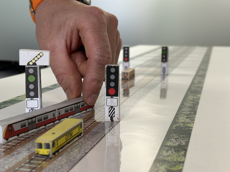
Physical simulation can then bring mapped situations into the training room. Learners can explore movements, communications, decisions, and consequences within a safe environment.
Technology and resources should support the process rather than define it. Ultimately, knowledgeable people must interpret the information and apply professional judgement.
How RPD Can Support Route Risk Management
RPD combines operational experience with practical safety, competence, and learning expertise. Therefore, our work connects risk identification with usable workforce development.
Our rail consultancy and training support helps organisations examine operational challenges and build longer-term capability. This approach can connect assessment findings with practical actions.
Route risk work may include hazard identification, risk assessment, mapping, and recommendations. In addition, organisations can use the outputs within training and ongoing competence assessment.
This connection matters because a risk register should influence everyday safety activity. Otherwise, valuable information may remain separate from operational decisions and staff development.
RPD can also support scenario-based learning through operational training and simulation expertise. Consequently, teams can explore route hazards within realistic and controlled exercises.
The exact approach should reflect each organisation’s routes, roles, evidence, and operating arrangements. Therefore, effective support begins with understanding the operational context.
Supporting Managers, Trainers, and Assessors
Route risk assessment gives managers a stronger basis for prioritising safety activity. Therefore, they can focus attention on higher-risk locations and recurring concerns.
Trainers can build learning around evidence rather than assumptions. Meanwhile, assessors can structure discussions around known hazards and expected responses.
This shared approach improves consistency. Because everyone uses the same risk information, teams can align training, competence, and operational assurance.
Route mapping may also reveal wider development needs. For example, repeated difficulty at one location could justify simulation, coaching, or practical observation.
Clear records support governance as well. Managers can show how identified risks influence training, assessment, briefing, control, and review activity.
Consequently, route risk management becomes part of ongoing safety management. It does not remain a document that teams consult only after incidents.
Final Thoughts
Route risk assessment and mapping turn operational hazards into practical learning. They help rail operators understand local challenges and prioritise attention more effectively.
The process supports stronger route knowledge, targeted training, and meaningful competence assessment. In addition, it prepares staff for degraded and emergency situations.
However, producing a map or risk register does not complete the task. Organisations must keep information current, involve staff, and apply findings consistently.
When these elements work together, route knowledge becomes easier to understand and use. Therefore, staff can make safer and more confident operational decisions.
For rail organisations, the result extends beyond improved documentation. It creates a stronger connection between route experience, workforce competence, and everyday safety management.